Here Are 4 Geological Sites of Rinjani National Park
Rinjani National Park is an extraordinary earth phenomenon that attracts many world researchers to study the process of volcanoes on the island of Lombok. Lombok Island is one of the most beautiful islands in Indonesia.
The discussion of the earth and the phenomena that occur in it is the science of geology. In this case, in general, geology discusses the material that forms the earth and all the processes that occur both within the earth or subsurface and those that occur above the earth’s surface.
Why is this interesting for us to discuss? Because the status of Mount Rinjani is a national park and has received international recognition. Recognition as the main site of the Global Geopark Rinjani Lombok and the core area of the Rinjani Biosphere Reserve Lombok.
Physical Condition
The Gunung Rinjani National Park area is a mountainous area with altitudes varying between 500-3,726 m above sea level, while the slope ranges from flat, moderate, heavy, and very heavy. It is what attracts many climbers to try the heights and slopes of the Rinjani area. The contours of the land vary which is very challenging.
The area of Mount Rinjani National Park is 41,330 ha with a length of 156.108 km of boundaries. This area occupies 9 percent of the area of Lombok Island. you can imagine the extent of this Rinjani National Park. In addition, the Mount Rinjani National Park is an Indonesian National Tourism Strategic Area. The Indonesian government is very focused on developing this area about the Super Priority Tourism Destination, Mandalika Lombok.
Geological site with Many Awards
Mount Rinjani National Park received several awards including:
World Legacy Award
Destination Stewardship category award from Conservation International and National Geographic Society on June 8, 2004. Gunung Rinjani National Park is considered to make a real contribution to promoting sustainable tourism principles related to nature conservation, economic benefits to local communities, and respect for cultural diversity.
Achievements in Building Technology
Other achievements in the performance of area management include building an information technology system for data collection in the Rinjani application, online ticketing in the e Rinjani application, CCTV monitoring of climbers and animal movements, solving PKTI Pesugulan problems and Otak Kokoq Joben tourist destinations through Cooperation Agreements and providing access to Conservation Partnerships and collaborative management of tourist destinations to the community.
The Geological Sites in Rinjani National Park
What are the geological sites in Rinjani National Park? let’s talk about it.
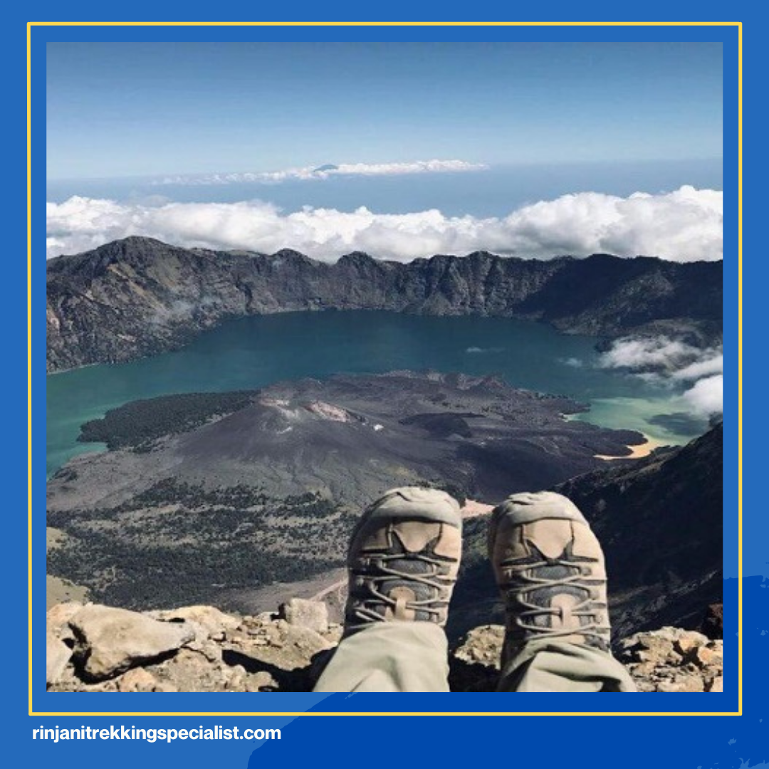
Samalas Caldera
The first geological site in Rinjani National Park is the Samalas caldera. The beauty and uniqueness of the landscape of Mount Rinjani National Park in the form of a caldera which is the highest caldera with an active volcano in Indonesia. This landscape of high aesthetic value is the result of a series of very powerful eruptions on Mount Samalas. The caldera is the result of the eruption of Mount Samalas in 1257. At the time, it was the largest eruption in the world in the last 7,000 years.
Where is Mount Samalas located? Mount Samalas, known as the old Rinjani, is now part of the Rinjani volcano complex. We can see the remains of the mountain by forming the caldera of Segara Anak Lake and Rinjani Mountain.
Mount Rinjani
Mount Rinjani is separated from the Samalas caldera with the status of the second-highest volcanic peak in Indonesia after Mount Kerinci in Sumatra. The area of Mount Rinjani has an altitude of 3,726 meters above sea level, including the peak of Mount Rinjani volcano and Rinjani Crater or Segara Muncar.
In addition, Mount Rinjani is a geological site that has the greatest geothermal potential. This is because the potential has been identified as a geothermal prospect around the old Sembalun caldera and is included in the Gunung Rinjani National Park area, protected forest and other use areas. The Sembalun geothermal prospect area has surface geothermal manifestations in the form of hot springs and alteration rocks. Hot springs are found in 3 different locations, namely in Sebau River, Kalak River, and White River. Geothermal manifestations in the form of altered or teralterated rocks are found exposed in 3 different locations, namely near the location of Sebau hot springs, Sembalun Bumbung, and east of Sembalun Lawang.
Segara Anak Lake
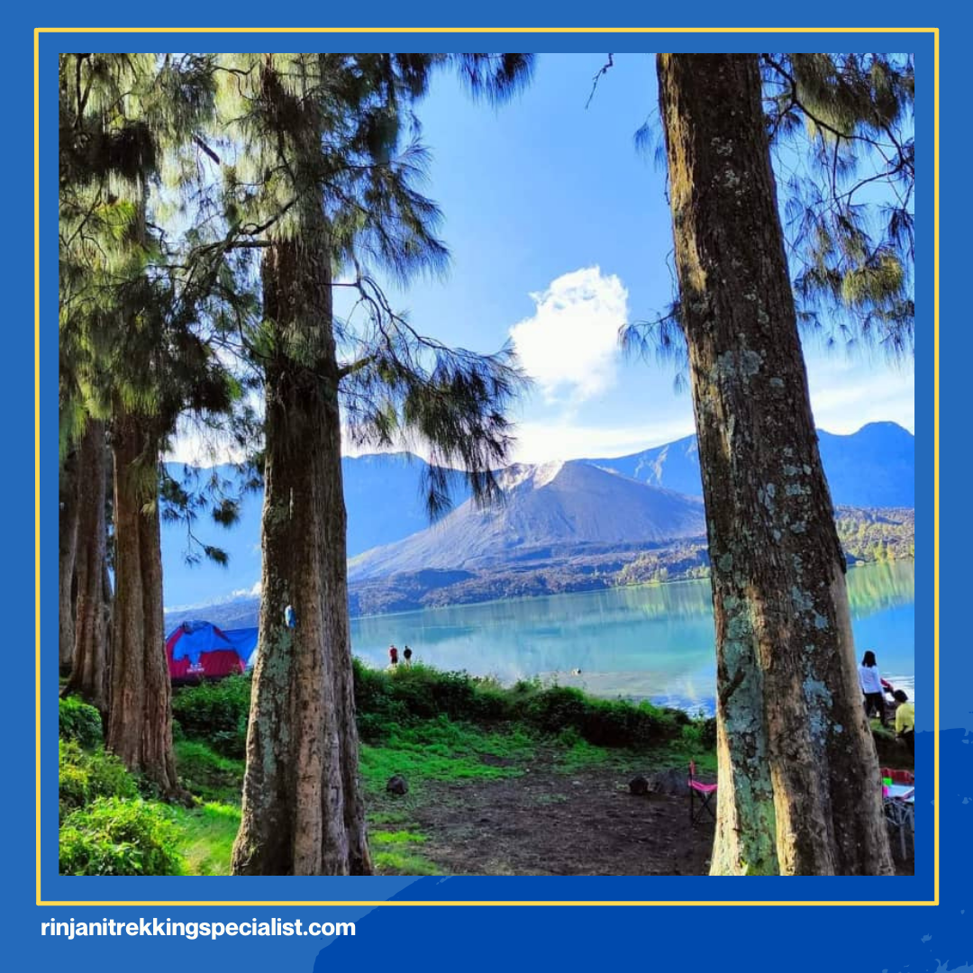
Segara Anak Lake, located at an altitude of 2009 m above sea level with a surface area of 11,126 ha and a depth of 160 – 230 m, which flows into the White River, holds potential energy to be developed into a power plant. So far, the utilization of water flow energy from the Gunung Rinjani National Park area for micro-hydro power plants in the White River and in Santong Village.
The ecological condition of Segara Anak Lake is silting due to erosion at the top and the entry of material from the 1944 eruption, so that the depth of Segara Anak Lake is only about 200m. The results of research conducted in 2007-2008 showed that the maximum depth of the lake was around 205 m. In addition, Segara Anak Lake is the largest warm-water volcanic lake in the world.
Read here: That’s Instagrammable! Rinjani, Anti-Mainstream Lake Tourism
Barujari Volcano

The existence of volcanic activity in the Samalas caldera after the 1257 eruption caused other volcanic peaks to appear in this area. These include the peak of Mount Barujari (2,376m above sea level). Then there is another mountain peak around Mount Barujari, namely the peak of Mount Rombongan (2,110 meters above sea level).
Mount Barujari is like a small mountain that emerges from the bottom of Lake Segara Anak. From the surface of the lake, the height of Mount Barujari is only about 300 meters. Mount Barujari and Mount Rombongan are mountains resulting from the eruption of Mount Rinjani in 1944.
Summary
Earth phenomena are indeed very interesting for us to discuss. Because of the wonders of nature, it resulted in many beautiful earth sites or places. As we know, the eruption of Mount Samalas is a phenomenon that causes other geological sites or mountains. The volcanic activity of the mountain hundreds of years ago formed the Segara Anak Lake with Mount Rinjani at the eastern end. And Mount Barujari has the nickname the son of Mount Rinjani.
Are you ready to visit the four most beautiful places in the world on the island of Lombok? There is the Samalas caldera, Mount Rinjani, Lake Segara Anak, and Mount Baru Jari.
Meanwhile, when you climb, we will pass through the beautiful caldera of Lake Segara Anak. therefore, it is important to know the travel route when climbing. For those of you who have never been there, don’t worry. Because the management of Mount Rinjani National Park cooperates with trekking organizers, guides, and porters. And no less important is to choose an experienced trekking organizer who has a good track record of service. Parman Trekker is a Rinjani trekking specialist who will guide hikers to four geological sites in Rinjani.
Parman Trekker
North Lombok, West Nusa Tenggara, Indonesia Post Code 83354
Mobile Phone : +081353144856